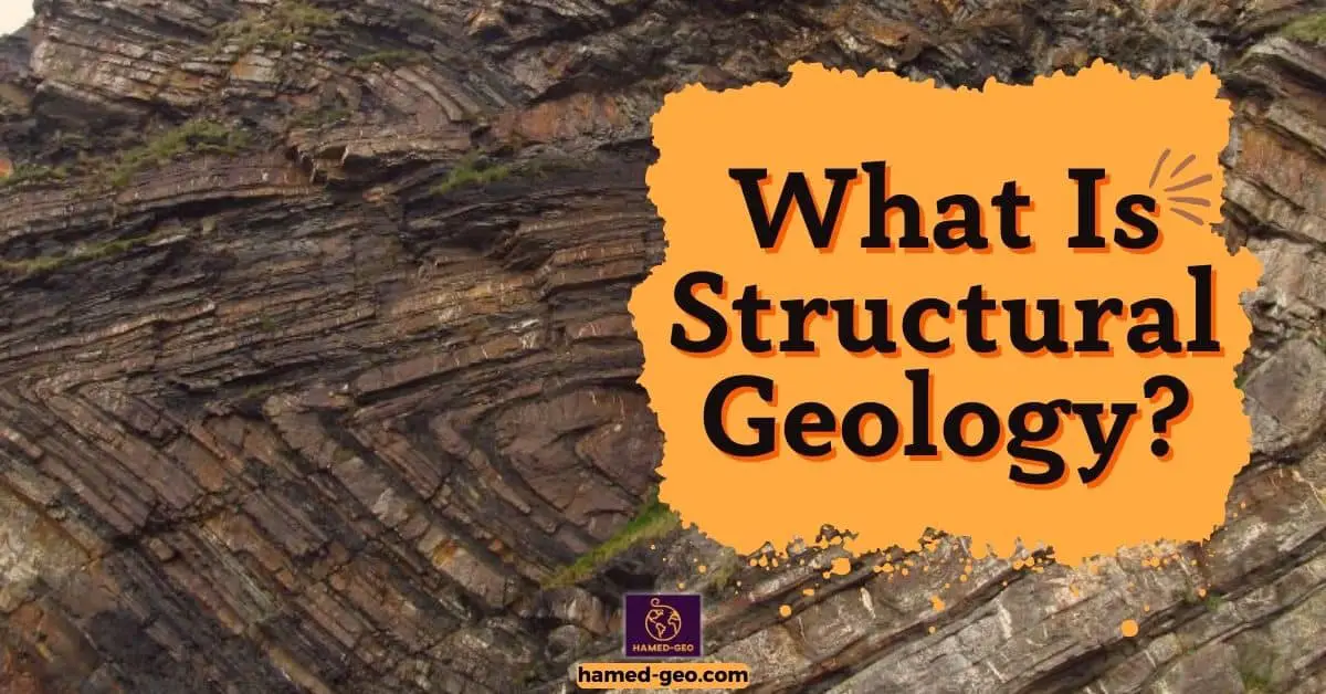
Structural geology, a sub-discipline of geology, focuses on the study of geological structures, such as folds, faults, and rock formations. The importance of this discipline is underscored by its broad application in various fields such as petroleum geology, economic geology, and engineering geology. It provides insights into the history of the earth’s deformation, which is crucial in understanding the formation and evolution of continents, seismic activities, and the formation of oil and gas reservoirs. Structural geologists, through their detailed analysis of rock deformation, provide valuable data that helps in predicting natural disasters like earthquakes and landslides.
The techniques and principles utilized in structural geology have evolved with advances in technology. For instance, the advent of Geographic Information Systems (GIS) and remote sensing technologies have revolutionized the way geological structures are detected and analyzed. These innovative tools allow geologists to gather more accurate data, which can be used to create three-dimensional models of the Earth’s structure. Such advancements have not only enhanced the accuracy of predictions but also increased the efficiency and speed of geological surveys.
Overview of Structural Geology
Structural Geology, defined as the study of the earth’s deformation due to tectonic forces, is crucial to understanding geological phenomena. This discipline investigates the mechanics and processes that result in the formation of geological structures, thereby revealing the earth’s history. The primary goals encompass deciphering geological events and predicting natural disasters. An overview of structural geology necessitates an examination of Plate Tectonics, which explains the movement and interaction of the earth’s crust, directly influencing the formation and evolution of geological structures.
Definition of Structural Geology
Bridging the gap from our previous discussion, let’s delve right into the realm of Structural Geology. Consider it as the branch of geology that studies the processes leading to the deformation of Earth’s crust. The focus rests heavily on the analysis of geological structures created by these deformations, such as folds, faults, and joints.
Moreover, Structural Geology does not just study the immediate effects of these deformations. It also looks into the resultant broader-scale features, such as mountain ranges and sedimentary basins. This particular field of study aims to understand the mechanical behavior of the Earth’s crust, its response to stresses, and the resulting deformation patterns and structures.
By doing so, it becomes instrumental in predicting areas with high seismic activity, planning the excavation of mineral resources, and solving environmental challenges. The fundamental knowledge of Structural Geology thus forms the backbone of multiple branches of earth science.
What Structural Geology Studies
Delving deeper into the heart of the subject, Structural Geology primarily aims to study the three-dimensional distribution of rock units with respect to their deformational histories. The focus remains on studying rock deformation on both a large, e.g., mountain-building process, and a small scale, such as the microscopic analysis of deformed minerals and rocks.
Intriguingly, this field of geology also examines past geologic environments and events by looking at geologic structures such as faults, folds, and joints. Moreover, it investigates the behavior of solid rocks subjected to mineralogical changes and deformation under varying pressure and temperature conditions.
Seismic studies also form an integral part of Structural Geology, aiding in the understanding of the internal structure of the Earth. Furthermore, the study of gravitational and magnetic anomalies can provide valuable insights into subsurface geology, contributing significantly to the broader understanding of Earth’s geology.
Goals of Structural Geology
As we delve deeper into the realm of structural geology, it is crucial to unravel the pivotal goals that this field of study strives to achieve. The primary objective of structural geology is to comprehend the processes that result in the formation of geological structures and to infer the past tectonic events experienced by the Earth.
An essential component of this study is the analysis of geological structures, which aids in the understanding of the Earth’s deformational history. This includes investigating rock deformation patterns and the forces responsible for such transformations. Moreover, structural geology aims to predict the locations of significant resources such as oil, gas, and minerals, thus playing a crucial role in exploration geology.
Additionally, the field endeavors to contribute toward assessing geological hazards. For instance, the study of fault lines and earthquake-prone regions can provide valuable insights into potential seismic activities. Therefore, the goals of structural geology are not only confined to theoretical understanding but also extend to practical applications in resource exploration and hazard assessment.
Plate Tectonics
The Theory of Plate Tectonics explains the large-scale movements of Earth’s lithosphere. This theory is reinforced by the evidence from Plate Boundaries, areas where plates interact, leading to various geological activities. These boundaries facilitate Plate Movement and Interactions, contributing to the dynamic nature of Earth’s crust. Such activities often result in the formation of distinct Tectonic Landforms. The idea of shifting continents was initially proposed by Alfred Wegener under the Continental Drift Theory, a precursor to the current understanding of plate tectonics.
Theory of Plate Tectonics
Imagine standing on a piece of Earth’s crust, feeling the subtle tremors and shifts beneath. This is the reality of the Theory of Plate Tectonics, a geological concept that revolutionizes our understanding of the Earth’s structure.
The theory posits that the Earth’s lithosphere, the rigid outer layer, is fragmented into several large and small pieces known as tectonic plates. These plates float on the semi-fluid layer of the asthenosphere beneath them.
And guess what? The tectonic plates are not static. They are constantly moving at varying rates, ranging from 1 to 10 centimeters per year, due to the convection currents in the underlying asthenosphere. This movement leads to the formation of major geological features and events such as volcanoes, earthquakes, and mountain ranges.
In sum, the Theory of Plate Tectonics provides a comprehensive explanation for the dynamic nature of the Earth’s crust, a blueprint of geological evolution.
Plate Boundaries
Delving deeper into the realm of geology, plate boundaries present an intriguing aspect of the plate tectonic theory. These boundaries mark the borders where tectonic plates meet and interact. This interaction can take place in three basic ways, creating three types of plate boundaries.
The first type is convergent boundaries, where plates move towards each other, often leading to the formation of mountain ranges, volcanoes, and trenches.
On the other hand, divergent boundaries are formed when plates move apart. This movement creates rift valleys and mid-ocean ridges.
Lastly, transform boundaries occur when plates slide horizontally past each other, characterized by earthquakes.
Each type of plate boundary has distinctive geological activities associated with it, underlining the dynamism of the Earth’s crust. This dynamic nature has profound implications for the Earth’s landscape and influences various geological phenomena.
Plate Movement and Interactions
Delving deeper into the realm of plate tectonics, Plate Movement and Interactions offers an intriguing facet of this expansive field. Bearing in mind that the earth’s lithosphere is divided into several large and small plates, the movement and interaction of these plates form the bedrock of seismic and volcanic activities.
Plates move apart at divergent boundaries, resulting in the formation of new crust. This phenomenon, typically observed in mid-ocean ridges, results in the spreading of the sea floor. On the contrary, plates come together at convergent boundaries, leading to the destruction of the crust. This action often leads to the formation of mountain ranges, deep-sea trenches, and volcanic islands.
Moreover, transform boundaries occur when plates merely slide past each other without the creation or destruction of the lithosphere. These zones are typically marked by earthquake activities. In essence, the dynamic movement and interactions of tectonic plates shape the Earth’s geology.
Faulting and Folding
Understanding the Theory of Faulting and Folding forms the bedrock of geological studies. Various Types of Faults and Folds exist, each with distinct characteristics and implications. Knowledge of these types is essential to comprehend the fundamental processes that underpin their formation. The formation process of both Faults and Folds can be attributed to factors such as tectonic forces, sedimentary loading and unloading, and isostatic adjustments. The exploration of Fault Formation and Fold Formation provides deeper insight into the dynamics of the earth’s crust and aids in predicting geological events.
Theory of Faulting and Folding
Imagine, for a moment, the intense energy forces that shape the surface of our planet. This dear reader, is where the theory of faulting and folding comes into play.
Faulting and folding are geological processes that occur due to the movement of the lithospheric plates. When these plates collide, separate, or slide past each other, they cause the Earth’s crust to deform, resulting in faults and folds.
Faulting refers to the fracturing of the Earth’s crust, with displacement of one side relative to the other. This process is a major factor in the formation of mountain ranges, valleys, and rifts. On the other hand, folding is the bending or warping of layers of rock under pressure. This mechanism forms the basis for the creation of hills, anticlines, and synclines.
The theory of faulting and folding is a fundamental part of geology, providing vital insights into the dynamic nature of Earth’s landscape.
Types of Faults
Building on the knowledge of plate tectonics, one can better understand the processes of faulting and folding. Let’s delve into the Types of Faults.
Faults, which are fractures in the Earth’s crust where significant displacement has occurred, can be broadly categorized into three types: normal, reverse, and strike-slip faults. In a normal fault, the hanging wall block moves downward relative to the footwall block. This movement is primarily caused by extensional forces and results in the lengthening of the Earth’s crust. Conversely, a reverse fault is characterized by the upward movement of the hanging wall block relative to the footwall block, due to compressional forces that shorten the Earth’s crust. Lastly, strike-slip faults involve horizontal displacement between the blocks, with no vertical movement. These are essentially shear stresses acting in the crust. Each type of fault provides insight into the tectonic forces at play in different regions.
Types of Folds
Venture now from the grandeur of moving continental plates to the intricate detail of geological origami – the formation of folds. In the context of geology, folds refer to bends or wrinkles in layers of rock caused by external stress. There are three primary types of folds: anticlines, synclines, and monoclines.
Anticlines represent convex up folds where the oldest rocks are in the core of the fold. Conversely, synclines are concave down folds in which the youngest rocks are in the core. Lastly, monoclines are folds whereby both limbs remain relatively horizontal, with a single steep dip in the earth’s surface.
These types of folds are not isolated phenomena but often coexist in fold-and-thrust belts, manifesting the fascinating complexity of our planet’s geological architecture. They are crucial in understanding the earth’s past and in guiding exploration for valuable resources.
Earthquakes
Earthquakes pose significant threats globally. Understanding their causes, which include plate tectonics and volcanic eruptions, is essential. Equally important is the Earthquake Magnitude, a quantifiable measure of the energy released at the earthquake source. This leads to Seismic Wave Propagation, the process by which energy travels through the earth’s layers. The energy is released as Seismic Waves, which cause the ground to shake. Studying these phenomena helps to comprehend Earthquake History, a record of seismic events that aid in predicting future earthquakes.
What Causes Earthquakes

Just as the earth’s crust moves and changes in the processes of faulting and folding, so too do the forces beneath our feet create another powerful geological phenomenon: earthquakes.
In the quest to understand what causes earthquakes, one must delve deep beneath the surface into the Earth’s lithosphere. At this depth, various tectonic plates interact with each other, causing stress to build up over time. This stress eventually leads to a sudden release of energy, creating seismic waves that ripple through the earth. The point where this energy release occurs is known as the hypocenter, while the point directly above it on the surface is the epicenter.
Scientific research has revealed that the majority of earthquakes are caused by the movement along faults, which are fractures in the Earth’s crust where blocks of rock have moved past each other. This movement can be triggered by a build-up of stress due to the slow but constant motion of tectonic plates.
Earthquake Magnitude
In the dance of tectonic plates, the magnitude of an earthquake serves as a measure of the energy released. Imagine a giant scale, where the numbers rise exponentially, translating to a tenfold increase in amplitude and approximately 31.6 times more energy released for each unit increase. This is the essence of the Richter scale, developed in 1935 by Charles F. Richter.
Now, bear in mind that the Richter scale is not the sole measure. The moment magnitude scale (Mw), for instance, offers a more accurate estimation of large, distant, or deep earthquakes. It calculates the total energy released by earthquakes.
Interestingly enough, the largest earthquake ever recorded, the 1960 Valdivia earthquake in Chile, reached a magnitude of 9.5 Mw. This just goes to show that the magnitude of an earthquake stands as a testament to the immense power Mother Nature holds in her hands.
Seismic Wave Propagation
Shifting from the impactful process of faulting and folding, the discourse now moves to another significant geophysical phenomenon- earthquakes. In particular, the spotlight turns to seismic wave propagation, a critical factor in understanding the dynamics of earthquakes.
When an earthquake occurs, it releases energy in the form of seismic waves. These waves propagate or travel from the source, known as the hypocenter, through various layers of the Earth. Seismic wave propagation is influenced by the characteristics of the Earth’s interior, including its density, temperature, and composition. Furthermore, the speed and direction of these waves can also be shaped by the geological structures they encounter, such as faults or folds.
For instance, seismic waves often slow down when they hit softer, less dense material and speed up when they encounter harder, denser material. This can lead to a phenomenon known as refraction, where the wave changes direction. Understanding seismic wave propagation, thus, provides valuable insights into both the nature of earthquakes and the Earth’s interior composition.
Volcanoes
To understand volcanoes, an examination of various Types of Volcanoes is essential. This leads to illuminating the Volcano Formation Process, revealing the dynamics behind these natural phenomena. To anticipate volcanic activities, Volcano Monitoring techniques are crucial. Studying the Volcano Geology History provides insights into past occurrences, helping predict future events. Finally, the composition and properties of Volcanic Materials are not only fascinating but also have significant implications for human life and the environment.
Types of Volcanoes

While the earth’s tectonic movements manifest in the form of earthquakes, they also give rise to another geological phenomenon – volcanoes. Delving into the realm of volcanology, it is vital to understand the different types of volcanoes.
Primarily, there are four main types: shield volcanoes, cinder cone volcanoes, composite (or stratovolcanoes), and lava domes. Shield volcanoes are characterized by their broad, flat shape, resembling a warrior’s shield. They are formed by highly fluid lava flows that travel a great distance before solidifying. On the contrary, cinder cone volcanoes are steep, conical hills formed by the accumulation of volcanic debris. Composite volcanoes, also known as stratovolcanoes, are the most common type, characterized by their large size and symmetrical shape. These are formed by alternating layers of lava flows and pyroclastic debris.
Volcano Formation Process
Just as the earth shakes under the power of quakes, imagine the very ground beneath feet swelling, bulging, and finally exploding in a fiery display of molten rock and ash. A dramatic scene, right? That’s the birth of a volcano.
Now, let’s dive into understanding the volcanic formation process. It all begins with the motion of tectonic plates beneath the earth’s surface. When these plates collide, one plate often subducts, or slides beneath the other. This causes parts of the subducting plate to melt, forming magma. This magma rises through the crust, and if it reaches the surface, a volcano is born.
Indeed, this phenomenon is not a simple or quick process. It can take thousands to millions of years for a volcano to form. The birth of a volcano is a testament to the immense, slow-moving power of geological forces.
In essence, the formation of volcanoes is a spectacular display of Earth’s interior dynamics at work.
Volcano Monitoring
Moving on from the heart-pounding unpredictability of earthquakes, imagine standing on the edge of a fiery abyss, where molten rock bubbles and roars. Welcome to the world of volcanoes. Delving into the topic of Volcano Monitoring, it’s fascinating to note the precision and complexity involved.
Multiple methods are employed to monitor volcanic activities. These include seismology, which tracks earthquake activities near volcanoes, and geodesy, which observes changes in the shape of the volcano. Gas measurements also form a crucial part of monitoring, as certain gases increase before an eruption.
Incredibly, remote sensing allows scientists to monitor volcanic activities from space! Advanced technologies like satellite imagery and thermal imaging help detect changes in temperature and the release of gases. Ground-based thermal cameras and gas sensors also contribute to the monitoring process.
These techniques provide valuable insights into the behavior of volcanoes, aiding in prediction and disaster management.
Subsidence and Landslides
Initially, the causes of subsidence will be assessed, followed by an exploration into the triggers of landslides. Next, a discussion on landslide mitigation strategies will commence, highlighting their vital role in reducing the impact of these geohazards. Furthermore, subsidence case studies will be analyzed to provide real-world examples of such events. Finally, the discussion will delve into the human impact on subsidence, emphasizing the significant influence of anthropogenic activities on these environmental processes.
Causes of Subsidence

As the smoke of volcanic eruptions recedes, the ground beneath takes center stage. After all, it’s not just volcanic activities that shake and shape our Earth. Subsidence, the sinking of land, is a potent and often overlooked force of nature.
One of the primary causes of subsidence is groundwater extraction. Excessive pumping of groundwater for agricultural, industrial, or residential use can cause the land above to sink. This is largely due to the fact that the removal of water causes the underlying soil to compact and lose its ability to support the weight of the land above.
Another significant cause of subsidence is the mining of resources. When minerals or fossil fuels are extracted from the ground, voids are left behind. These voids can collapse under the weight of the overlying land, leading to subsidence.
Lastly, natural processes such as the dissolving of limestone or other soluble rocks can lead to the formation of sinkholes, a dramatic and dangerous form of subsidence.
Causes of Landslides
Transitioning from the fiery wrath of volcanoes, we now plunge into an equally terrifying natural phenomenon: landslides. The causes of landslides are numerous and often intertwined, creating a domino effect that can lead to catastrophic consequences.
Primarily, landslides may be triggered by geological causes, such as weak or sensitive materials, weathered materials, sheer or slick slopes, and morphological conditions. Additionally, human activities like deforestation, quarrying, changes in natural water levels, and construction work can significantly contribute to the likelihood of landslides.
Equally crucial are hydrological causes which include changes in pore water pressure and groundwater movement. Furthermore, physical causes such as intense or prolonged rainfall, snowmelt, rapid thawing, and earthquakes, may disturb the stability of a slope, thereby triggering landslides.
Lastly, vegetation changes play a pivotal role in landslides.
Landslide Mitigation Strategies
Transitioning from the fiery wrath of volcanoes, our attention now shifts to a different type of geological hazard, albeit equally devastating — landslides. These natural disasters can wreak havoc on communities, but with the right strategies, their impact can be significantly mitigated.
Landslide mitigation strategies typically encompass three main categories: avoidance, stabilization, and protection. Avoidance strategies involve careful land-use planning, including zoning regulations that restrict construction in high-risk areas. Stabilization methods aim to prevent landslides from occurring and can include drainage control, slope grading, and reinforcement with retaining walls or anchors. Lastly, protection measures are designed to shield infrastructure and property from landslides and may include constructing deflection walls or installing flexible barriers.
It is crucial to note that successful mitigation relies heavily on accurate landslide hazard assessments. Such assessments require both historical data and geotechnical investigations to predict landslide-prone areas.
Natural Resources
Groundwater resources are essential for human survival, yet they are under threat due to over-extraction and pollution. Similarly, mineral resources play a significant role in economic development but are finite in nature. The exploration of oil and gas resources also presents a double-edged sword, providing energy but also contributing to climate change. Sustainable utilization of resources is therefore of paramount importance, ensuring these resources can meet both current needs and those of future generations. However, this is not without its challenges, as the extraction and use of natural resources often lead to significant environmental impact, necessitating balanced and mindful approaches.
Groundwater Resources

Despite the potential devastation caused by subsidence and landslides discussed in the preceding section, it is essential to diverge the focus toward the trove of natural resources. Groundwater resources form a significant part of these natural assets.
Imagine this: Groundwater is indeed a hidden treasure, providing about 30% of global freshwater needs. It’s a critical source for agriculture, making up 63% of total irrigation water. Moreover, it’s a lifeline for over 2.5 billion people who rely on it for drinking water.
Yet, it’s an under-appreciated resource. Groundwater is extracted and used without a clear understanding of the hydrogeological conditions and recharge rates. The growing demand, coupled with climate change impacts, exacerbates the situation. Sustainable management of groundwater resources is therefore vital to ensure long-term availability and quality.
This includes, but isn’t limited to, the implementation of effective monitoring systems, the promotion of water-saving technologies, and the enforcement of legal frameworks for groundwater protection.
Mineral Resources
Shifting away from the perils of subsidence and landslides, let’s turn our focus to the wealth that lies beneath the surface of the earth. Mineral Resources embody a significant part of this wealth, acting as the backbone of many global economies.
Minerals are non-renewable resources that take millions of years to form. These resources are extracted for a myriad of purposes such as construction, manufacturing, energy production, and technological advancements. For instance, the extraction of iron ore fuels the production of steel, a fundamental element in the construction industry. Similarly, rare earth elements such as neodymium and dysprosium are indispensable in the manufacturing of high-tech devices.
Interestingly, the economic value of mineral resources fluctuates. It is dictated by factors such as demand and supply, technological developments, and geopolitical tensions. For instance, in recent years, graphene, a single layer of carbon atoms, has gained significant economic value due to its potential use in creating stronger and lighter materials.
Oil and Gas Resources
After delving into the somber realities of subsidence and landslides, the focus now shifts to a brighter facet of the Earth’s crust: its wealth of Oil and Gas Resources.
These resources exist in several forms, including crude oil, natural gas, and shale gas, lying deep beneath the Earth’s surface. They are primarily formed from the fossilized remains of ancient marine organisms, subjected to immense heat and pressure over millions of years.
Oil and Gas Resources represent a significant part of the world’s primary energy supply, accounting for about 57% of the total, according to the International Energy Agency in 2019. They fuel industries, power transportation, and provide heat and light for homes and businesses.
Despite their importance, these resources are non-renewable and finite. Their extraction and utilization also pose significant environmental challenges, including potential spills, air and water pollution, and contribution to climate change. Thus, efficient and sustainable extraction and consumption practices become essential.
Structural Mapping
In the domain of Structural Mapping, various methods are utilized to comprehend geological complexities. Geological Mapping serves as a visual representation of the earth’s surface. This is closely linked with Remote Sensing, a non-intrusive method of data collection. Similarly, Geophysical Surveying, using advanced technologies, is employed to identify sub-surface characteristics. The integration of these techniques generates Geological Cross-Sections, providing a vertical perspective of the earth’s composition. Finally, Field Methods in Mapping are applied to capture tangible data through direct observation. Each of these subtopics contributes to a comprehensive interpretation of geological structures.
Geological Mapping
Imagine for a moment the vast, uncharted world beneath our feet. This is where the journey into Geological Mapping begins. An essential tool in the study of the earth’s subsurface, it provides a detailed representation of the distribution and orientation of geological features.
In the realm of geological mapping, the focus is on the identification and measurement of rock units on the surface of the earth. These rocks hold clues to the underlying structures and processes, offering a window into the dynamic history of our planet. Technological advancements have aided in the improvement of geological mapping accuracy, but fieldwork remains pivotal in gathering accurate data.
The practice of geological mapping requires a keen understanding of the principles of stratigraphy and petrology, as well as a strong grasp of spatial techniques. A well-executed geological map is more than a mere depiction of geology; it is the blueprint of the earth. This blueprint guides the quest for resources and the prediction of geological hazards, making it indispensable in the field of earth sciences.
Remote Sensing

Moving away from the bounty of natural resources, the focus now shifts like a satellite eye in space, towards the science and art of Structural Mapping. Diving into the first topic, Remote Sensing, is a pivotal method in structural mapping that employs satellite or aircraft-based sensor technologies to detect and classify objects on Earth. It is widely used in geological mapping due to its ability to cover large areas and capture fine details. It can identify mineral deposits, analyze rock types, and assess the impact of natural disasters, such as landslides and earthquakes. Sensors such as multi-spectral and hyperspectral sensors are used to capture images in different spectral bands, revealing geological features not visible to the naked eye. For instance, Landsat and Sentinel satellites have been instrumental in geological mapping, providing valuable data for resource exploration and environmental monitoring. Thus, remote sensing offers a bird’s eye view of the earth’s geology, indispensable in modern geological studies.
Geophysical Surveying
Following the exploration of natural resources, let’s pivot toward another vital aspect of geology: geophysical surveying. This technique forms an integral part of structural mapping, offering substantial insights into mapping and exploration.
Geophysical surveying is a systematic collection and interpretation of geophysical data. These techniques tap into the physical properties of the earth’s crust, such as magnetic and gravitational fields, to generate imagery of subsurface structures. Subsurface geophysics utilizes a variety of tools, including magnetometers, gravity meters, and seismic refraction instruments, to gather data and create a detailed geological map.
A noteworthy application of geophysical surveying is in the exploration of mineral and energy resources. By identifying anomalies in the Earth’s magnetic field or gravitational field, geophysicists can detect subsurface mineral deposits or oil and gas reservoirs.
In short, geophysical surveying plays a pivotal role in structural mapping, offering a window into the subsurface world that remains unseen to the naked eye.
Applied Structural Geology
In the realm of Applied Structural Geology, various subtopics play a crucial role. Evaluation of Natural Hazards and Evaluation of Natural Resources involves assessing potential risks and benefits derived from geological phenomena. Subsequently, Geotechnical Engineering encompasses the application of geological principles to civil engineering projects. This field is intricately linked with Stress and Strain Analysis; understanding how rocks respond to external pressures. Lastly, Rock Deformation Analysis investigates the structural changes in rocks under varying conditions. These subtopics together provide a comprehensive understanding of structural geology and its practical applications.
Evaluation of Natural Hazards
Moving from the theoretical to the applied, let’s delve into the practical aspects of structural geology. One significant application lies in the Evaluation of Natural Hazards.
Earthquakes, volcanic eruptions, and landslides are all natural hazards that structural geologists strive to understand and predict. Indeed, these phenomena are intricately linked with the Earth’s structural makeup, and extensive geological investigations can provide crucial data to mitigate risks. For instance, structural mapping can identify regions prone to landslides, enabling early warning systems and preventive measures. Additionally, a detailed understanding of fault systems can help predict seismic activity, which can minimize the impact of earthquakes.
Evidently, the role of structural geologists extends beyond academia and into society. Through their work, they contribute to enhanced safety measures, more accurate risk assessments, and ultimately, to a better prepared and more resilient society.
Evaluation of Natural Resources
The application of structural geology in assessing natural resources is critical. It serves as a guide for the exploration and extraction of minerals and hydrocarbons. The structural patterns of the earth, identified through mapping, can reveal the locations of oil, gas, and mineral deposits. It has been discovered that around 62% of the world’s oil and gas reserves are found in structural traps.
The role of structural geology extends beyond just locating these reserves. It also directs the safe and efficient extraction of these resources. Detailed structural analysis can identify the safest areas for drilling or mining operations. Moreover, it helps to determine the most cost-effective extraction techniques. As such, structural geology is a vital tool in the sustainable management of natural resources.
Therefore, a comprehensive understanding of applied structural geology significantly aids in the effective evaluation of natural resources.
Geotechnical Engineering
Having delved into the depths of structural mapping, it’s time to turn the page and explore its practical applications. Geotechnical Engineering, a significant sub-discipline of applied structural geology, deserves special mention here.
In the realm of geotechnical engineering, structural geology plays a pivotal role. It provides the tools and techniques necessary for site investigations for civil engineering projects. It’s crucial for understanding the mechanical behavior of soils and rocks, which directly impacts the stability of structures built on them. For instance, the analysis of rock and soil samples provides insights into their strength, compressibility, and permeability, which are vital parameters for designing foundations, tunnels, dams, and other civil engineering structures.
Geotechnical Engineering also makes use of structural geology principles in slope stability analysis. It is by understanding the geological structures, stress fields, and failure mechanisms that engineers can predict and mitigate slope failures, thus ensuring the safety of structures and inhabitants.
In conclusion, structural geology plays a pivotal role in the understanding of Earth’s geological phenomena. It enables the study of Earth’s plate tectonics, earthquakes, volcanoes, and natural disasters like subsidence and landslides. Furthermore, it helps in the exploration of natural resources and in conducting structural mapping.
Moreover, the application of structural geology in industries like oil and gas, mining, and construction is significant. It provides essential knowledge for the safe and efficient extraction of resources, and for planning and executing construction projects. Thus, structural geology is integral to both scientific understanding and practical applications.
[…] Structural geology is the study of the deformation of Earth’s crust rocks at a scale ranging from the microscopic to […]