Plate Tectonics Definition
Plate tectonics is the one of essential discoveries of the 20th century. The Earth’s surface is composed of lithosphere which is broken into many giant pieces called plates that move around the globe over the plastic/ductile upper mantle asthenosphere. Tectonics is the interaction between these plates.
Plate tectonics is the theory that describes the deformation of the plates as these plates slide past, go over, go under or collide with each other and the forces acting on them.
Plate tectonics also explains magma generation, volcanic and earthquake formation, mountain building, mid-oceanic ridge formation, and deep-sea trenches formation. It also gives an indication how was the continents and oceans looks like in the past.
What is continental drift theory?
Alfred Wegener is a German meteorologist and geophysicist who wrote the book “The origin of continents and oceans”, and gives a great hypothesis about continental drift theory which will change the long-held assumption about the fixed position of continents and ocean basins.
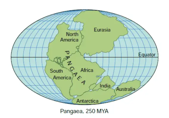
Wegener proposed that a huge single supercontinent comprising all Earth’s continents once existed. This was named Pangaea which means all lands. Wegener hypothesized that Pangaea began to break into smaller continents about 200 million years ago during the early Mesozoic. These continents then drifted to their present positions over millions of years. See below figure 1.
Wegener supported his theory with many considerable pieces of evidence such as the fit of some continents, distribution of fossils, ancient climates, geological features, and rock types.
The continents fit like jigsaw puzzles such as Africa with South America because of the noticeable similarity between the coastlines on opposite sides of the Atlantic Ocean.
What Causes Tectonic Plates To Move?
Mantle convection or convection currents are the main driving force or “engine” for large-scale plate tectonics processes as agreed nowadays. They are driven by a combination of three thermal activities. First, heat is generated from the heat loss from Earth’s core. The second is heat from the decay of radioactive isotopes. Third, cooling of upper lithospheric slabs that sink into the mantle.
The mantle consists of hot and weak ductile/plastic rocks that exhibit fluid-like convection currents. If you think simply about convection currents like heating a pot of water, cause the base material to rise to the surface and start cooling and become denser to sink back to the bottom where it’s reheated until it achieves sufficient buoyancy to rise again. Actually, the model is more complex than what we described.
Now let’s explain in detail how the convection currents mechanism work. Hot currents rise beneath oceanic ridges which carry magma that pushes the lithosphere apart at the ridge. The newly hot lithosphere finally becomes cool and denser to pull the rest of the lithosphere downwards at the subduction zone creating downward convection currents as shown in figure 2.
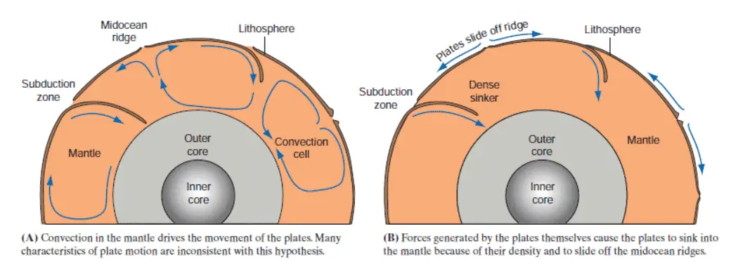
There are two main mechanisms that have been proposed to explain why plates move. First, a slab pull is the downward movement of a plate subducting at an extreme angle through the mantle; this movement tends to pull the farther side of the plate away from the ridge due to the high density of the rocks. Second, ridge push is generated by a gravity-driven mechanism developed out of the upheaved position of the oceanic ridge, which causes the new-formed crust to move away after becomes cool and denser. However, the slab pull movement is faster than the ridge push movement by comparing motion rates.
What Do The Tectonic Plates Float on?
Plate tectonics theory suggests the lithosphere has broken into many huge plates. These plates fundamentally float on an underlying layer of more dense, plastically flowing rocks called the asthenosphere.
How Many Tectonic Plates are There on Earth
Our lithosphere is divided into seven major plates, these are Pacific, North American, Eurasian, African, South American, Antarctic, and Australian plates. The largest plate is the Pacific plate which constitutes almost fully oceanic crust.
The smaller plates are Arabian, Philippine, Cocos, Juan de Fuca, Caribbean, Nazca, and Scotia plates.
See the below figure 3 to locate plates on the map.
What is the Plate Tectonics Boundaries?
The easiest way to recognize plate tectonics boundaries is by looking at the map showing the locations of earthquake belts. These belts mark exactly the locations of plate boundaries. There are other different indicators of plate boundaries such as mountain belts, deep-ocean trenches, and volcanoes.
There are three major plate tectonics boundaries according to geologist’s classifications on the basis of relative motions. They are divergent plate boundaries, convergent plate boundaries, and transform plate boundaries. We’ll explain each type in detail.
1- Divergent Plate Boundaries
A Divergent plate boundary or a spreading boundary forms when a plate splits and is then pulled apart along rift zones. As the split plates move apart, new oceanic lithosphere is created along the divergent boundary. As the separate continental pieces drift apart with diverging plates, a new and continually enlarging ocean basin is formed. Thus, divergent plate boundaries are marked by tensional stresses that generate normal faults along the margins of the separating plates. see below figure 4.
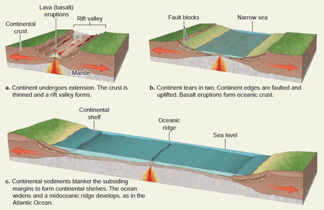
The best live example of this type is the East African Rift zone as the African continent breaks apart to form a steep-walled, wide depression called a rift valley. Eventually, this rift valley will open to create a new oceanic crust by volcanic activity due to underlying asthenosphere is close to the surface.
Most of the divergent plate boundaries are hidden beneath the sea, and they are some of the most active volcanic areas on the Earth such as the Mid-Atlantic Ridge which separates the South America and Africa plates. These volcanic activities create more than half of the Earth’s surface during the last 200 million years along divergent plate boundaries.
2- Convergent Plate Boundaries
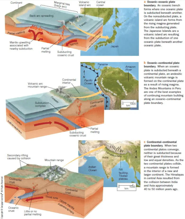
A convergent plate boundary is a position where tectonic plates move toward one another, which may collide or move down into the mantle. Convergent plate boundaries are associated with mountain building, crustal deformation, metamorphism, earthquakes, and igneous activity. Thus, they are very complicated geologic systems.
If both plate boundaries are oceanic crust, one should be subducted beneath the other by the process called subduction characterized by a deep-sea trench. The colder and denser plate-older will descend into the mantle. The descending plate will sink into the mantle where it is heated and ultimately absorbed or consumed. The islands of Tonga and Marianas of the western Pacific were created by ocean-ocean convergent plate boundaries.
If one plate is a continental plate that is lighter than the oceanic plate, the oceanic plate will subduct beneath the continental plate. Folded mountain belts are formed by compression which deforms the continental margin. An example of this type is the Cascadia subduction zone of the northwestern United States.
If both converging plate boundaries are continental crust, neither can subduct into the mantle, although one plate can abduct the other for a short distance. High deformation occurs by compression stresses and both plates are eventually combined into a single continental block with a very high mountain range. The best example of this type is the great Himalayan mountain chain formed when the Indian and Eurasian plates collided. See figure 5 for types of convergent plate boundaries.
3- Transform Plate Boundaries
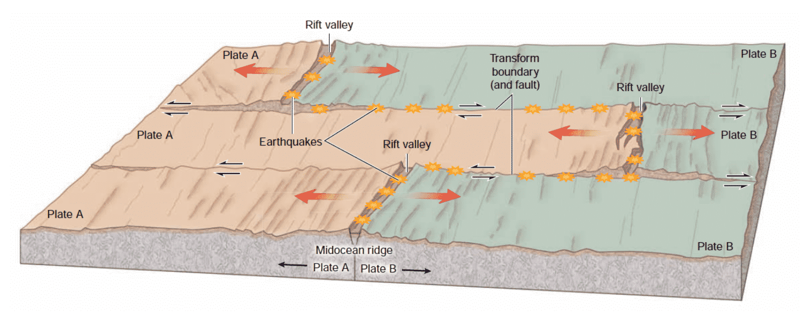
Transform plate boundaries are locations where plates of lithosphere slide past one another without diverging or converging and without destroying or creating lithosphere but as the plates move, the crust is fractured or broken. A strike-slip fault or transform fault occurs along this plate boundary. The transform fault is parallel to the direction of relative plate movement. Volcanic activity is not common at transform faults. The best typical continental transform fault example is the San Andreas Fault in California which separates the North American and Pacific plates. See below figure 6.
What is the evidence for plate tectonics?
1- The Fit of the continents
The eastern coast of North America could fit against northwestern of the coast of Africa and Antarctica, Australia, and India could all connect to the southeast of Africa. While, Asia, Europe, and Greenland could pack against the northeastern coastline of North America. Actually, Pangaea can be created by joining all the continents with remarkably few gaps or overlaps.
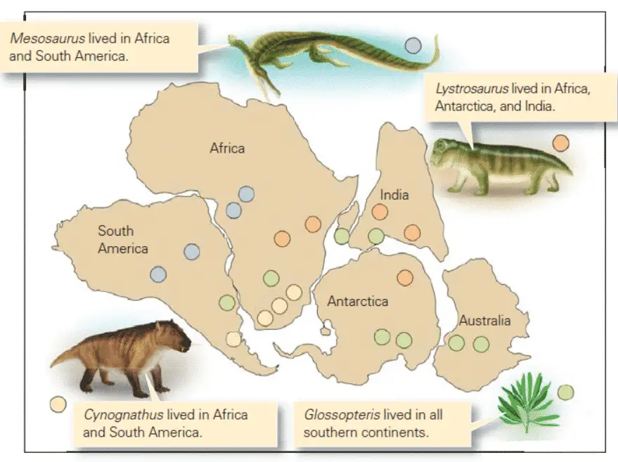
2- The Distribution of Fossils
Similar fossils species of many different plants and animals had been found on widely separated continents that once lived near or on land as shown in the figure. This explains that the continents were once connected. By swimming or floating the organisms could migrate in the ocean, but the migration of land-dwelling animals will be very difficult. See below figure 7 for the distribution of fossils.
3- Matching structures and types of rocks
Large geological structures and a distinctive assemblage of rocks existed on the western coast of Africa and the eastern coast of South America now separated by an ocean. The only explanation is these continents were once adjacent to each other and thus could have been composed of continuous blocks. Also, the characteristics of layers of rocks in southern Greenland, Scandinavia, northwestern Africa, and Great Britain nearly resemble the Appalachian Mountains of the United States.
4- Glaciation Evidence
During the late Paleozoic Era about 300 million years ago, glaciers covered large portions of southern Australia, Antarctica, southern India, southern Africa, and southern South America. This indicates these continents once existed near the south pole. The glacier deposits of this age are distinct and can be easily recognized. Nowadays, all southern continents except Antarctica lie close to the equator, far away from a latitude that could produce glaciation. On the other hand, present-day Northern Hemisphere continents show no proof of glaciation during this time. This evidence can’t be explained by immovable continents.
[…] takes place at the deeper layers of the crust, at the margins of colliding and subducting tectonic plates, where the rock is deformed and forced into a new direction. Regional metamorphism is fueled by the […]
[…] Tectonics is the study of forces and displacements that deform rocks within the […]
[…] called magma. There’re many places in Earth’s crust that contain cracks and breaks as result of plate tectonic movement, which are called faults and fissures. At these locations, the magma starts to seep up from the […]
[…] the continental environments usually play a more significant role in determining the climatic and tectonic conditions and may contain economically significant mineral resources (Li, C., Hu, X., Wang, J., Vermeesch, […]
[…] tectonic (and, precisely, plate-tectonic) setting is used to classify sedimentary basins. For modern basins, this is rather simple, but for […]
[…] are linked to folding and plate tectonics movements, sometimes being (and only part) of their formation or structure […]
Awesome post.
Thanks
[…] The nature of the trap can be either structural or stratigraphic. These traps are formed by tectonic events such as faulting, folding, and diapirism. The oil and gas are stored in the reservoir rock. The […]
[…] scientists to develop models of the Earth’s mantle and its dynamics, which can be used to study plate tectonics and other geological […]
[…] On the other hand, metamorphism refers to the changes that occur in rocks due to high temperatures and pressures, usually associated with deep burial or tectonic activity. Unlike diagenesis, metamorphism involves the recrystallization of minerals, resulting in the formation of new mineral assemblages and the destruction of original sedimentary features. Metamorphic rocks often exhibit a distinct foliation, which is a parallel alignment of mineral grains. The intensity of metamorphism can vary, ranging from low-grade metamorphism, which involves slight changes in mineralogy and texture, to high-grade metamorphism, which results in the complete reconstitution of the rock. Metamorphism can occur over a wide range of temperatures and pressures, and it is often associated with mountain-building processes such as subduction and collision of tectonic plates. […]
[…] environment. These hazards are primarily caused by the movement and interaction of the Earth’s tectonic plates. The Earth’s crust is divided into several large plates that float on the semi-fluid […]
[…] theory? It’s the big picture – the reason the crust is moving and smashing in the first place. Plate tectonics explains why California’s got that San Andreas fault giving everyone the jitters, or how the […]
[…] Plate Tectonics, for example. Ugh, we’ve all heard the term, right? But here’s the thing: it’s […]
[…] They map how heat oozes out from the core, driving mantle convection—the literal engine of plate tectonics. Without that heat flow data? We’d have zero clue why continents […]
[…] useful for predicting earthquakes and volcanoes and learning about the formation of mountains and plate tectonics. Geologists can tell us how long the Earth has been around and what kind of conditions have existed […]