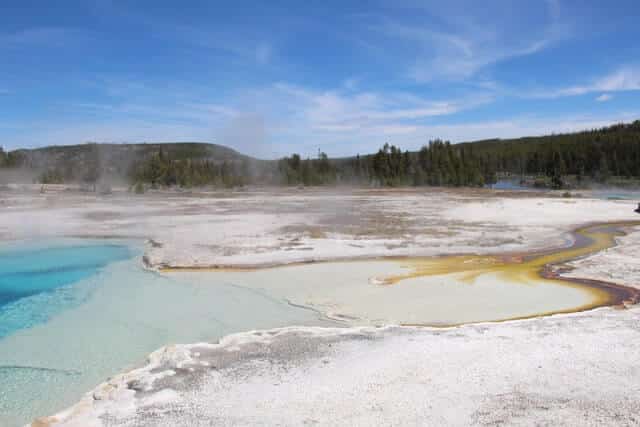
A sedimentary basin is a section of the earth’s crust covered by a thick series of sedimentary rocks. Hydrocarbons are generally found in sedimentary basins, with igneous and metamorphic rocks filling in the gaps.
A tectonic (and, precisely, plate-tectonic) setting is used to classify sedimentary basins. For modern basins, this is rather simple, but for ancient basins, it is more challenging. List of some of the most essential criteria that could be employed, from the most descriptive at the top to the most genetic at the bottom:
- The nature of the fill
- paleogeography and geometry
- Tectonic setting
Intracratonic Basins
1.1 Location and tectonic setting of Intracratonic Basins:
In the anorogenic zones and on the cratons.
1.2 Processes of tectonics and sedimentation in Intracratonic Basins:
These basins appear to be unrelated to plate tectonics. They’re supposed to be the result of extremely gradual thermal sinking (100 million years is a reasonable estimate) as a result of a heating event beneath the continent’s lithosphere. The causes of depression below the initial crustal level, on the other hand, are unknown. Erosion and lithospheric stretching appear to be unavoidable during the thermal uplift. Because subsidence is so slow that no depression of the lithosphere’s upper surface occurs, depositional circumstances are essentially the same as elsewhere; Only now is the succession thicker. There are fewer and smaller diastems in these successions, which makes them more complete (a diastem is a brief halt in sedimentation with little or no erosion before sedimentation resumes), showing that the basin was submerged while the surrounding areas emerged.
1.3 Intracratonic Basins Size and shape:
Equidimensional, rounded, hundreds of kilometers across.
1.4 Sediment fill of Intracratonic Basins:
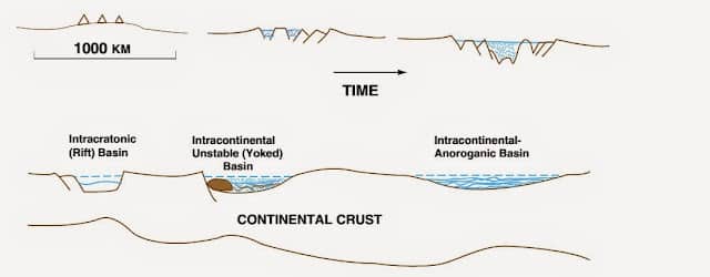
Hundreds of meters of shallow water cratonal sediments (carbonates, shales, sandstones), thicker and more complete than surrounding cratonal portions but still quite thin.
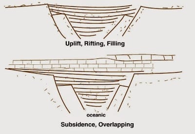
Rift Basins
2.1 Tectonic setting and location of Rift Basins:
Within continental lithosphere on cratons.
2.2 Processes of tectonics and sedimentation in Rift Basins:
Lithospheric extension on a craton causes major rifts, which are thought to be generated by regional sub-lithospheric heating. Some of these rifts continue to open, eventually forming ocean basins with oceanic crust as the floor instead of continental crust; the basin term refers to this stage of rifting. Rifts that do not fully extend up to the ocean basins, (Because a close and parallel gap becomes the master rift, possibly.) are grounded by thinning continental crust rather than fresh oceanic crust in some circumstances. East Africa’s rift valleys are a modern example. In eastern North America, the Triassic–Jurassic Connecticut and Newark basins constitute an old example. Despite the fact that the land slope in the East African rifts is far from the crest of the peaks, and remarkably little silt enters the rift basins, sediment supply from the elevated fault blocks’ neighboring highlands is usually abundant.
2.3 Size and shape of the Rift Basins:
Long and narrow, linear, with thousands of meters of width and thousands of kilometers of length.
2.4 Sediment fill in Rift Basins:
Siliciclastics from coarse to fine, mainly non-marine sediments; lacustrine sediments; inter-bedded basalts.
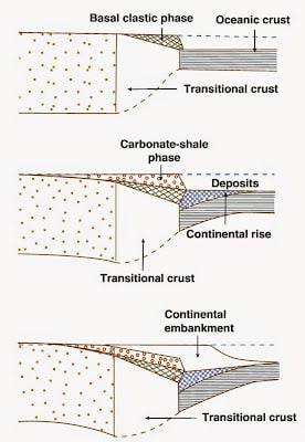
Passive Margin Basins
3.1 Tectonic setting and location of the Passive Margin Basins:
Approximately encompassing the rifting-induced transitioning from a continental to an oceanic crust, as well as the creation of a full-fledged ocean basin along passive continental boundaries.
3.2 Processes in Passive Margin Basins:
On either side of the ocean basin, the zone of continental crust extensional thinning and heating subsides as it opens by spreading. The transition from continental to oceanic crust is subsiding. is covered by a sediment wedge, either siliciclastics produced on land or carbonates developed in situ, generating the continental shelf and slope we see today. In ancient times, this was known as the miogeocline. The weight of the deposited sediments exacerbates the subsidence, causing the continental margin to bend down sharply. As a result, deposition does not occur in a basinal structure, but rather in a spherical geometry rather in a concave upward geometry.
3.3 Size and shape of Passive Margin Basins:
Hundreds of kilometers wide and thousands of kilometers long; piecewise straight to straight, in most situations, within significant detail irregularity.
3.4 Sediment fill in Passive Margin Basins:
The continental shelf’s extensive shallow-marine siliciclastics and carbonates, which are thickening seaward, are overlapping and cover the during the rifting and early opening, and older deposits were deposited down. These sediments graduate or interfinger seaward to form turbidites are deep marine coarse and fine siliciclastics or re-sedimented carbonates, abyssal plains are formed by generating underwater fans just at foot of a slope and fill the deepest regions of the ocean basin.
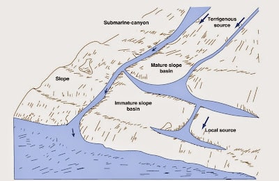
Fore-Arc Basins
4.1 Location and tectonic setting of Fore-Arc Basins:
In ocean–ocean subduction, between both the open palm subduction complex just centerline of the trench and the volcanic arc; in ocean-continent subduction, between the overriding continent and the open palm subduction complex just inboard of the trench.
4.2 Fore-Arc Basins Processes:
As subduction continues, a low area forms between the internal volcanic arc and the extremely high outer arc significant and increasing by subduction created by the subduction in magmatism, usually below sea level. Tectonically isolated from the initially nearby lands, there are possibly ancient instances of such fore-arc basins. Another type of fore-arc basin be arise between the overriding continent and the outlying arc after an arc-continent collision. The high terrain of the tectonically active continent is most likely to fill these basins. Direct reconstruction of their tectonic setting would be difficult later due to continent-continent collision.
4.3 Size, shape of Fore-Arc Basins:
Thousands of km long and tens of kilometers wide; typically arcuate.
4.4 Sediment fill of Fore-Arc Basins:
Non-marine siliciclastic fluvial to deltaic deposits transition deep into the siliciclastics of the deep sea, principally Deposits of sediment-gravity flow, along the arcward margin, all of which are interbedded with arc derived volcanic flows and pyroclastics. The thickness of a piece can be thousands of meters of deposits of sediment-gravity flow.
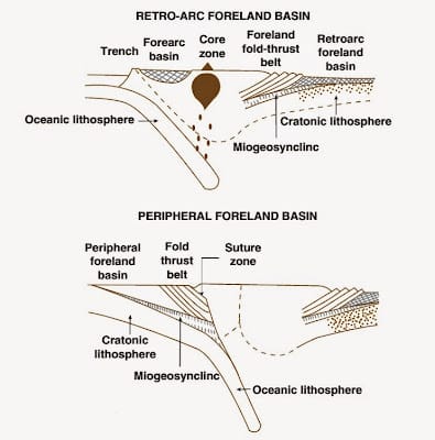
Foreland Basins
5.1 Foreland Basins tectonic setting, location, and processes:
Loading from thrust sheets migrating toward the continental interiors as a result of deformation and crustal shortening forms retro-arc foreland basins on stable continental after continent-continent collisions, crust in an ocean-continent subduction zone forms, as do peripheral foreland basins from thrust sheets developing in the subducted plate’s continental crust. Both forms are asymmetrical, with the deepest areas being closest to the inserted thrust sheets. Over time, they tend to drift out from the arc or sutures zone. To fill them, sediments from mountainous terrain linked with compression and thrusting are used.
5.2 Size, shape of Foreland Basins:
Hundreds to hundreds of km long, tens to thousands of meters wide; frequently has various lengths of development; often arcuate or discrete arcuate, reflecting subduction.
5.3 Sediment fill in Foreland Basins:
If the basin is flooded, coarse, fluvial siliciclastics thin and fin often go to shallow-marine sandstone-shale sequences distant from the arc or suture. The thickness of the layer can be measured in tens of thousands of meters. In foreland basins, molasse facies, thick non-marine conglomerates, are deposited.
Pull-Apart Basins
6.1 Pull-Apart Basins tectonic setting and location:
On a local scale, along significant Faults in the continent or oceanic crust that are strike-slip or transform.
6.2 Pull-Apart Basins Processes:
When a Movement along a strike-slip fault tends to induce strain because it is stepped or curved rather than straight, in which the fault’s walls are torn away from each other ( compression, in which the fault’s walls are pushed against one another (this is called compression) gaps or basins form in the tensional segments, which are refilled with silt from the neighboring high crust.
6.3 Pull-Apart Basins Size and shape:
Rhomboidal basins are common in pull-apart basins. Their size ranges from nearly equidimensional early in their existence to elongated afterward. The widths vary from a few tens of kilometers to many tens of kilometers, while the lengths vary from a few tens of km to tens of thousands of kilometers Some basins are much smaller than others.
6.4 Sediment fill in Pull-Apart Basins:
The continental crust basins, which are the most sedimentologically significant, are filled with water and with thick non-marine to Alluvial fans are marine coarse to fine clastics. flowing either lake deposits or restricted marine habitat deposits. In certain cases, the basin’s outskirts are encrusted with thick marine turbidites. Facies typically vary dramatically laterally, and lithologic unit thickness may be only slightly more or even less than the lateral extent. Bed-by-bed measurements have been used to calculate the total section thickness. of the section should be avoided since elongation of the basin occurs simultaneously with deposition.

[…] understand how this works, it’s helpful to know a bit about the geology of sedimentary basins. Sedimentary basins are regions where layers of sediment (like sand, clay, and rock) have […]